How We Picked
We focused on lakes worth specifically planning around, not just ones you pass through on the way to somewhere else. That means a mix of glacier-carved alpine basins inside national parks, big open-water reservoirs for sailing and walleye fishing, and quiet Seeley-Swan Valley spots where you can set a kayak in the water and barely see another boat. For each pick, we included the best season, the nearest town, and a reason it earns a place on this list. If you want a broader starting point for the state, the Montana Travel Guide is a good place to begin before drilling into specific lakes.
Flathead Lake
Flathead Lake is the largest natural freshwater lake west of the Mississippi, stretching 28 miles long and up to 15 miles wide in the Flathead Valley between Kalispell and Polson. The water is cold, deep, and clear enough to see the rocky bottom in the shallows. By midsummer, surface temperatures reach the low 60s Fahrenheit, which makes it swimmable but not tropical. Yellow Bay State Park on the east shore has a good swimming area and a boat ramp. Bigfork sits at the northeast corner of the lake with a marina, a small arts scene, and a few solid restaurants worth stopping at.
Wild Horse Island State Park sits near the lake's center and is reachable only by boat. It's home to bighorn sheep, mule deer, bald eagles, and a small herd of wild horses that have grazed there for generations. You can rent a kayak or canoe from outfitters in Bigfork or Polson and paddle out, though the crossing runs about 1.5 miles and the lake can build rough chop with afternoon winds. Late July is the peak of cherry season at the orchards along the west shore near Rollins and Lakeside, and roadside stands sell Flathead cherries for a few weeks before the harvest wraps up. Flathead is squarely inside Glacier Country, about 30 to 45 minutes south of the park's west entrance.
Lake McDonald
Lake McDonald is the largest lake inside Glacier National Park, roughly 10 miles long and 1.5 miles wide on the park's west side. It's known for the flat, colorful stones on its shallow bottom, visible through the clear water from the shoreline at Apgar Village near the lake's south end. Lake McDonald Lodge, a 1914 Swiss-chalet-style property listed on the National Register of Historic Places, sits on the eastern shore and operates as an NPS concession hotel from mid-June through mid-September.
Going-to-the-Sun Road begins its climb from the east shore of Lake McDonald and runs all the way up to Logan Pass and across to St. Mary. Kayak and canoe rentals are available at Apgar, which also has a small visitor center, a campground, and a handful of lodging options. The road to Apgar stays passable year-round, but services shut down after late September. If you plan to drive Going-to-the-Sun Road to Logan Pass, timed vehicle reservations are required for the corridor between Apgar and St. Mary from late May through mid-September.
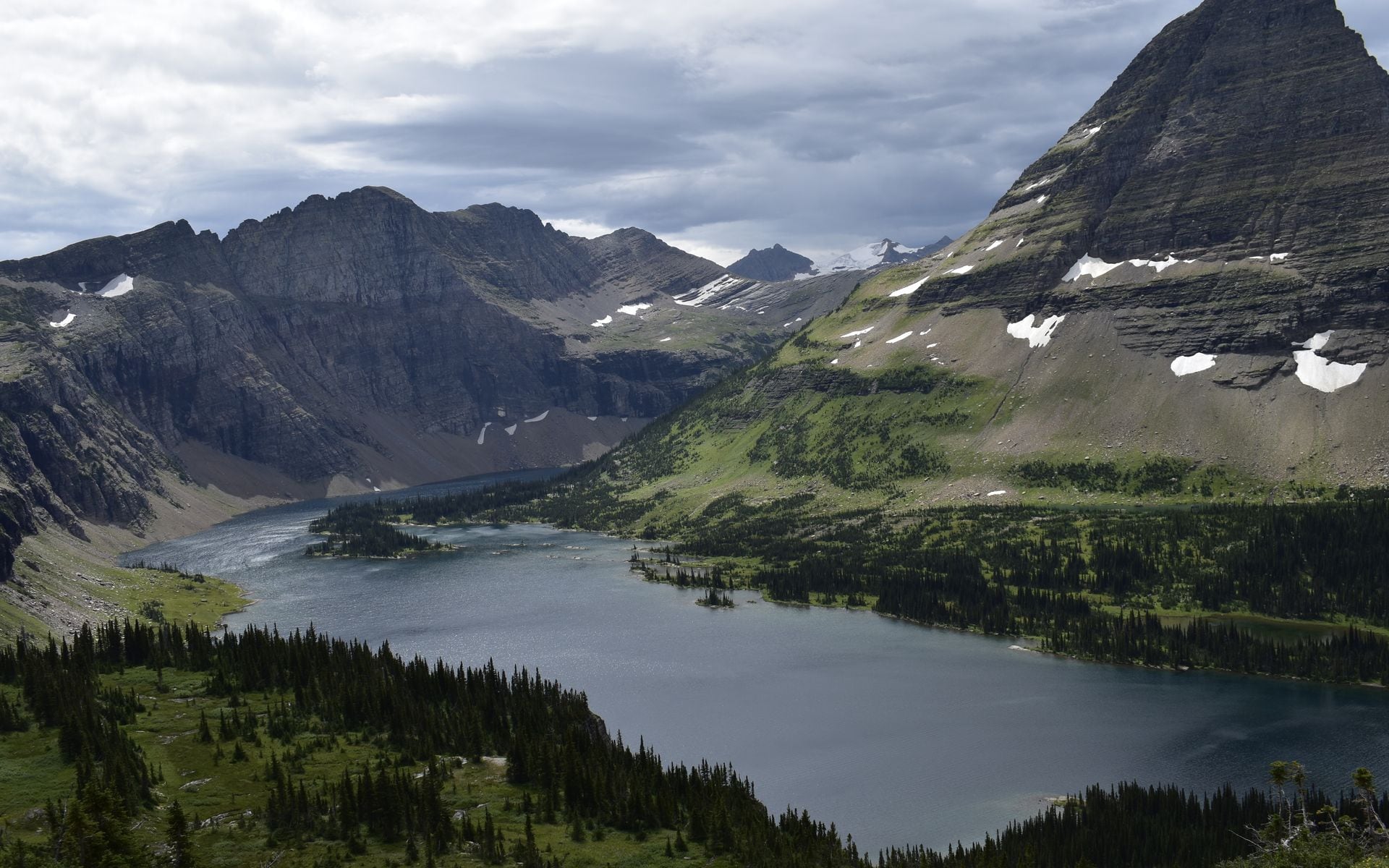
St. Mary Lake
St. Mary Lake is on the eastern side of Glacier National Park, at the foot of the Going-to-the-Sun Road's east approach. It runs about 10 miles long and sits at 4,484 feet elevation, framed by the Livingston Range on the north and Going-to-the-Sun Mountain on the south. Wild Goose Island, a small tree-covered outcrop near the lake's center, is one of the most photographed spots in the park and appears in nearly every Glacier travel piece for a reason.
The St. Mary entrance and visitor center are open from late May through mid-October. A campground at the east end of the lake handles tent campers and RVs. Boat tours depart from the Rising Sun boat dock on the lake's north shore during the summer season. The St. Mary area borders the Blackfeet Nation, and the views east from here open onto the Great Plains in a way that feels completely unlike the west side of the Continental Divide.
Fort Peck Lake
Fort Peck Lake is not what most people picture when they think of Montana, but it earns its place on this list. The reservoir covers roughly 245,000 acres on the Missouri River in Valley County, deep in the remote northeast corner of the state near the town of Glasgow. Fort Peck Dam, completed in 1940, is one of the largest hydraulic earthfill dams ever built, and the lake it created ranks among the largest reservoirs in the US by surface area.
The fishing is the main draw: walleye, northern pike, paddlefish, and sauger all thrive here, and angling pressure is low relative to the size of the water. The shoreline winds through more than 1,500 miles of raw Missouri Breaks badlands, and the surrounding prairie is also one of the better spots in eastern Montana to encounter pronghorn, mule deer, and upland birds. For a fuller look at where wildlife concentrates across the state, see the guide to best places to see wildlife in Montana. Glasgow is about 17 miles east of the dam on US-2. From Billings, plan on roughly four hours of driving to reach the area.
Georgetown Lake
Georgetown Lake sits at 6,378 feet in the Flint Creek Valley, about 25 miles west of Anaconda on MT-1 and roughly 40 miles northwest of Butte. At that elevation, the water stays cold well into summer, rarely exceeding 65 degrees even in August. It is a popular summer fishing and camping lake for southwest Montana residents, with kokanee salmon, rainbow trout, and burbot among the species anglers target. The boat ramps accommodate everything from small canoes to pontoon boats.
In winter, Georgetown Lake becomes one of the better ice fishing destinations in the state. Anglers drill through the ice from December through February chasing kokanee and burbot, and the lake draws a dedicated local crowd. Philipsburg, about 7 miles east on MT-1, is one of the more authentic old mining towns left in southwest Montana. The town has a sapphire shop where you can sluice for gems, a brewpub, and an old main street that hasn't been over-developed. If you need lodging near this area, Montana Hotels and Lodges has options across the region.
Holland Lake
Holland Lake is about 75 miles northeast of Missoula via MT-83 through the Swan Valley, at 3,840 feet elevation in the Flathead National Forest. It's a small lake, less than a mile across, but the setting earns it a place on this list: the Swan Range rises sharply from the east shore, and a waterfall spills down the cliff at the lake's head where Holland Creek drains from the Bob Marshall Wilderness above.
Holland Lake Lodge, a well-established Montana wilderness lodge, operates on the north shore with cabins, guided trail rides, and boat rentals. The trailhead here accesses the Bob Marshall Wilderness and the Swan Crest, and the routes heading into the Bob are serious backcountry with significant elevation. The road in from MT-83 is paved. The Swan Valley towns near Holland Lake are worth knowing; see the list of best small towns in Montana for picks like Seeley Lake and Condon nearby.
Canyon Ferry Lake
Canyon Ferry Lake is a 25-mile-long reservoir on the Missouri River, about 15 miles east of Helena off US-12. It's one of the most used fishing and boating reservoirs in central Montana, partly because Helena is close and the Bureau of Reclamation maintains more than a dozen developed campgrounds and boat ramps around the shoreline. Rainbow trout, walleye, yellow perch, and smallmouth bass draw anglers from across the region.
Canyon Ferry is the first of three Missouri River reservoirs in a chain heading north. Hauser Lake sits immediately downstream, and Holter Lake lies further north near Wolf Creek, where steep canyon walls and the Gates of the Mountains area make for dramatic boating and camping. Helena's regional airport (HLN) has direct flights from Seattle and Salt Lake City, making this stretch of central Montana accessible without a long drive from Bozeman or Missoula.
Seeley Lake
Seeley Lake sits at the south end of a chain of connected lakes in the Seeley-Swan Valley, about 60 miles northeast of Missoula via MT-83. The town of Seeley Lake is right on the water and has a handful of small resorts, a gas station, and a couple of restaurants. Compared to Flathead Lake, it runs quieter and smaller, with far less motorboat traffic and a more laid-back feel.
The Clearwater Canoe Trail is the main draw for paddlers: a 4-mile float along the Clearwater River connecting several lakes in the chain, passing beaver dams, osprey nests, and loons. Early mornings in August are the best time to spot loons calling on the water before the boat traffic picks up. The Mission Mountains Wilderness and Swan Valley provide trailheads within a short drive of the lake for anyone who wants to add hiking to a paddling trip.
Quick Comparison
For swimming, sailing, and full amenities, Flathead Lake is the obvious pick. For scenery inside a national park, Lake McDonald and St. Mary Lake belong in a separate category. Fort Peck Lake is the choice for remote reservoir fishing in eastern Montana with very low pressure. Georgetown Lake and Seeley Lake work well for anyone based in southwest or western Montana who wants a weekend lake without driving to Glacier. Holland Lake is the best option if you want wilderness lodge access combined with Bob Marshall trailheads. Canyon Ferry Lake is the most practical choice for anyone flying into Helena (HLN) and building a trip around central Montana.
Frequently asked questions
What is the largest lake in Montana?
Flathead Lake is the largest natural freshwater lake in Montana and the largest natural freshwater lake west of the Mississippi River. It covers about 189 square miles in the Flathead Valley between Kalispell and Polson. Fort Peck Lake is larger by surface area but is a man-made reservoir, created by Fort Peck Dam on the Missouri River in northeast Montana.
Are Montana lakes warm enough to swim in?
It depends on the lake and the time of year. Flathead Lake typically reaches the low 60s Fahrenheit at the surface by July and August, which most swimmers find cold but manageable. Smaller, shallower lakes in the Seeley-Swan Valley can warm a bit more in the shallows during summer. Alpine lakes inside Glacier National Park, including Lake McDonald and St. Mary Lake, stay considerably colder, often in the 50s even in late August.
Can you camp right on Flathead Lake?
Yes. Montana State Parks operates several campgrounds directly on the Flathead Lake shoreline, including Finley Point, Wayfarers, Yellow Bay, Big Arm, and West Shore state parks. Sites fill fast in July and August, and reservations through the Montana State Parks reservation system open in the spring. Expect to pay roughly $20 to $35 per night (estimate) depending on site type and season.
Which Montana lakes are inside national parks?
Glacier National Park contains more than 700 lakes, but the most visited are Lake McDonald on the west side and St. Mary Lake on the east side. Swiftcurrent Lake in the Many Glacier area and Two Medicine Lake in the park's southwest corner are also worth seeking out. Yellowstone National Park has three Montana-side entrances, and while Yellowstone Lake is the park's centerpiece, most of it sits in Wyoming.