Why Visit Missouri River Country
Missouri River Country covers the northeast quadrant of Montana, from the Hi-Line (US Highway 2) south to the Fort Peck Reservoir and east to the North Dakota border. The region holds Fort Peck Reservoir, one of the largest man-made reservoirs in the United States at 134 miles long and roughly 245,000 surface acres, surrounded by 1.1 million acres of the Charles M. Russell National Wildlife Refuge. The Upper Missouri River Breaks National Monument adds 375,000 acres of BLM-managed breaks, coulees, and river bottom through which 149 miles of the Missouri flow as a federally designated Wild and Scenic River. That is a lot of open country, and almost all of it is publicly accessible.
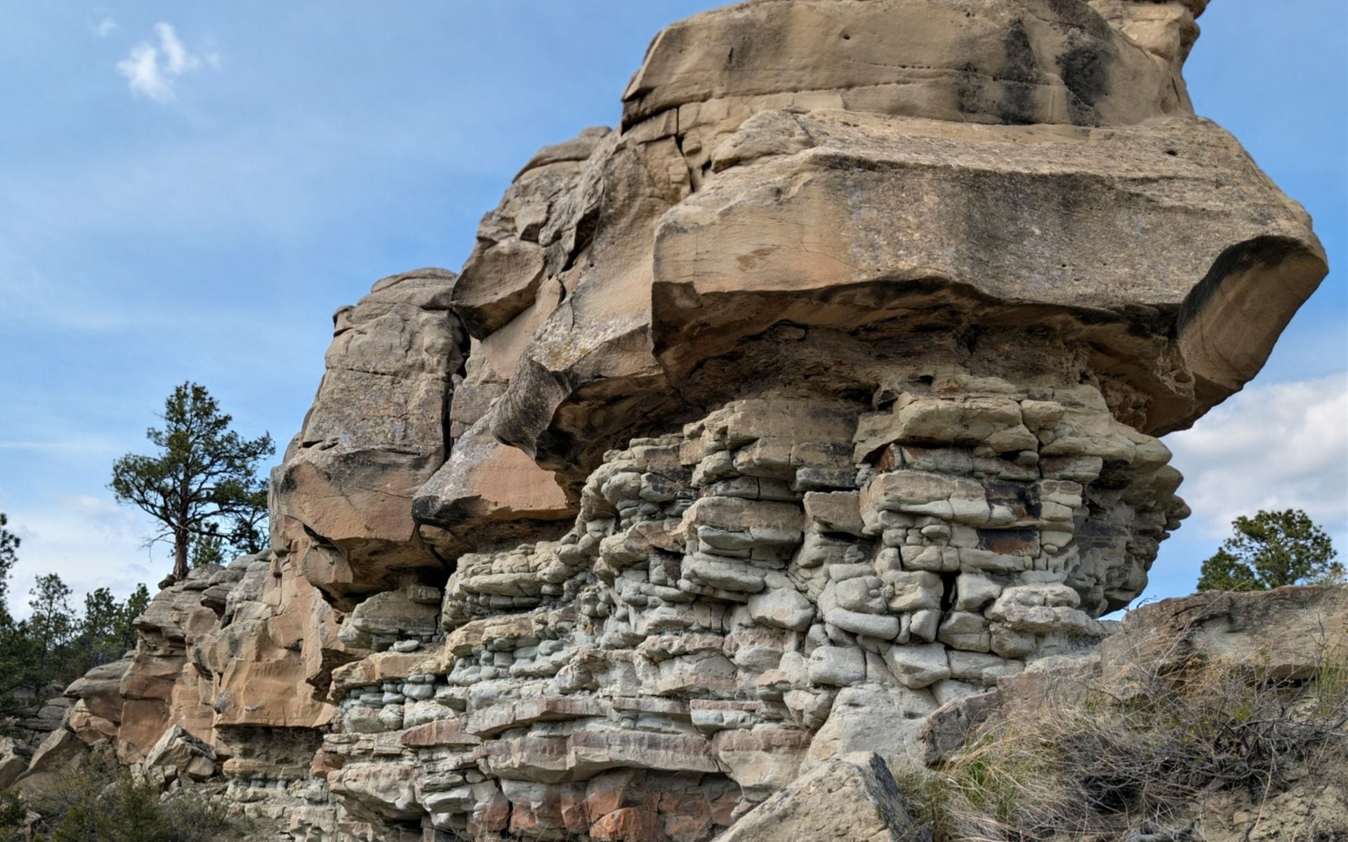
This is not a region built around resort infrastructure. There are no ski mountains, no national park entrance stations, and no tourist corridors with competing coffee shops. What the region offers is scale, solitude, and a river landscape that looks almost unchanged from when Meriwether Lewis wrote about the White Cliffs section of the Missouri in May 1805, describing them as 'seens of visionary inchantment.' Those same sandstone formations still rise 50 to 150 feet above the water today. Before you commit your full trip to this corner of Montana, the Montana Travel Guide can help you see how Missouri River Country fits into the broader state picture, but if you have three to four days to spend beyond the usual parks circuit, this region earns every mile.
Top Places in Missouri River Country
Fort Peck anchors the southern edge of the region. The Fort Peck Dam, completed in 1940 as one of the largest hydraulic earthen fill dams ever built, holds back 134 miles of reservoir. The town of Fort Peck itself is a New Deal-era company community built to house dam workers, and it still has a 1934 wooden summer playhouse, the Fort Peck Theatre, that runs productions in July and August. The Fort Peck Interpretive Center beside the dam displays a full-size T-rex skeleton replica and exhibits on the Hell Creek Formation fossils recovered from the breaks country to the south. Hell Creek State Park, about 26 miles north of Jordan on a gravel road, sits at the southeast end of the reservoir and is the main boat launch and camping hub for the southern lake.
Malta sits on US-2 about 70 miles west of Glasgow and gives access to Bowdoin National Wildlife Refuge, 15,500 acres of wetlands and shortgrass prairie seven miles east of town. Birding at Bowdoin from mid-May through mid-June can reach 230 or more species on a productive day, with white pelicans, American avocets, black-crowned night herons, and piping plovers among the draws. The Phillips County Museum in Malta holds a well-preserved T-rex skeleton and gives context to the dinosaur fossil record concentrated in this corner of the state.
Fort Benton, on US Highway 87 in the western edge of the region, is one of the oldest continuously inhabited towns in Montana and the starting point for the Wild and Scenic Missouri paddling route. Steamboats ran here from St. Louis through the 1870s, and the riverfront levee district is listed on the National Register of Historic Places. Glasgow, population roughly 3,200, is the largest service town in the region and sits at the junction of US-2 and US-191. Havre, about 115 miles west of Malta along the Hi-Line, offers more lodging and restaurants than anywhere else in northeast Montana, and the Havre Beneath the Streets tour walks visitors through the underground storefronts and tunnels dating to the town's 1887 origins. Several of these towns rank among the Best Small Towns in Montana for travelers who want authentic character over polish.
Top Things to Do
Paddling the Wild and Scenic Upper Missouri is the defining experience of the region. The 149-mile stretch from Fort Benton to the Fred Robinson Bridge on US-191 takes most paddlers five to seven days by canoe or kayak. The first two days cover the White Cliffs section, where the river bends through formations that look nothing like the wheat fields and breaks you drive through to get here. This segment has no road access, no cell service, and almost no other boats during the week. Several outfitters in Fort Benton rent canoes and can arrange vehicle shuttles; guided trips typically run in the $150 to $250 per person per day range (estimate). Book ahead if you want a guided trip in June or July, the peak paddling window.
Fishing on Fort Peck Reservoir draws anglers specifically for walleye, which thrive in the reservoir's cold, clear water and grow to trophy sizes. Northern pike in the 30-inch range and sauger are common secondary targets. Boat launches are located near Fort Peck Dam and at Hell Creek and Nelson recreation areas. The fishing season runs year-round, but ice fishing in January and February attracts dedicated locals who know the reservoir's walleye move into shallower bays. Summer fishing pressure on the reservoir is moderate compared to more accessible Montana lakes, which is part of the appeal.
Wildlife watching across the 1.1 million acres of the Charles M. Russell National Wildlife Refuge is best in early morning from April through October. The refuge holds pronghorn, mule deer, elk, bighorn sheep, black bear, and extensive prairie dog town networks that attract ferruginous hawks and burrowing owls. White pelicans appear on the reservoir in numbers from May through September. The auto tour routes near the CMR refuge headquarters east of Malta are passable in a standard passenger vehicle; the deeper two-track roads into the Breaks require high clearance. Download offline maps before leaving Malta or Glasgow, because cell coverage disappears entirely in the breaks country and can stay out for stretches of 40 or more miles.
Where to Stay
Glasgow has the most consistent motel options in the region, with several properties along US-2 ranging from about $80 to $140 per night (estimate). Malta and Havre offer comparable chains and independent motels at similar price points. Fort Benton has a handful of smaller inns and a historic hotel on the riverfront, well-positioned for paddlers starting the Wild and Scenic run. Camping is the dominant option for anyone spending time at Fort Peck or in the Breaks. The BLM allows dispersed camping throughout the Upper Missouri River Breaks National Monument at no fee, and Hell Creek and Nelson State Recreation Areas have developed sites with vault toilets and fire rings for roughly $15 to $28 per night (estimate). For a full comparison of lodging options across Montana's regions, Where to Stay in Montana covers the choices by area.
Reservations matter during peak walleye fishing season (late June through August) and during the few annual events that draw visitors to Fort Peck, including summer theatre weekends. Outside those windows, walk-in availability is generally fine across the Hi-Line towns. If you plan to paddle the Wild and Scenic Missouri, most Fort Benton outfitters can point you to lodging for the night before your launch.
Getting There and Around
Great Falls International (GTF) is the most practical commercial airport for Missouri River Country. From GTF, Malta is about two and a half hours east on US-2, and Glasgow is another 70 miles farther, adding about an hour. Billings Logan International (BIL) works for travelers focusing on the southern parts of the region, including Hell Creek and the Fort Peck area via US-191 north, which puts Jordan about three and a half hours out. Glasgow has its own regional airport (GGW) with limited scheduled service; verify current connections before depending on it as a primary arrival point.
A rental car is not optional in northeast Montana. The distances between services are real: Glasgow to Malta is 70 miles, Malta to Havre is another 110 miles, and the roads between towns are two-lane with limited fuel stops. US Highway 2, the Hi-Line, is the main east-west corridor and is well-maintained year-round. US Highway 191 runs south from Malta through the Breaks to Lewistown and eventually to Billings. Back roads into the Charles M. Russell Refuge and the Missouri Breaks are gravel or two-track and can become impassable in wet conditions due to the clay-heavy soil. After rain, even a pickup with four-wheel drive can get stuck. Check local conditions in Malta or Glasgow before heading in.
Best Time to Visit Missouri River Country
May and June are the strongest months for both birding and paddling the Upper Missouri. River levels are favorable through June, Bowdoin NWR is at peak activity from mid-May through mid-June, and the cottonwoods along the river bottom are fully leafed out by late May. Temperatures are comfortable, generally in the 60s and 70s°F during the day, though nights can still drop below freezing through mid-May. The prairie wildflowers on the breaks country are at their best in late May.
July and August bring summer fishing on Fort Peck Reservoir to full strength, with long daylight hours and boat traffic picking up on the lake. Daytime temperatures across the northeast plateau often reach the high 80s to low 90s°F. The river canyons trap heat, so paddling is best done in the morning. September is underrated: cooler air, fewer people, and pronghorn rut activity beginning across the grasslands make it a strong month for wildlife watching. Winter in northeast Montana is severe, with temperatures regularly dropping below 0°F from November through February, and most visitor services reduce hours or close seasonally. Plan your visit between May and September unless ice fishing on Fort Peck is specifically on your list.
Frequently asked questions
Is Missouri River Country worth visiting if I only have a week in Montana?
It depends on what you are after. If national parks, mountain scenery, and easy access to services are the priority, Glacier or Yellowstone country will give you more return on a single week. Missouri River Country suits travelers who specifically want remote paddling on the Wild and Scenic Missouri, serious walleye fishing on Fort Peck Reservoir, or Lewis and Clark history in a landscape that has not changed much since 1805. If you have 10 or more days and want to see a side of Montana that most visitors miss entirely, the Upper Missouri Breaks and the CMR Refuge are worth the drive east from Great Falls (GTF).
What towns are worth a stop in Missouri River Country?
Fort Benton is the most historically rich, with a preserved steamboat-era riverfront and the launch point for the Wild and Scenic Missouri paddle route. Malta gives you access to Bowdoin NWR and a good natural history museum. Glasgow is the most service-oriented and the practical base for Fort Peck Reservoir fishing. Havre offers more hotel and restaurant options than anywhere else along the Hi-Line and is worth a morning stop for the Havre Beneath the Streets underground tour. Many of these qualify among the Best Small Towns in Montana for travelers who value real character over tourist infrastructure.
Can I paddle the Wild and Scenic Upper Missouri without a guide?
Yes. The 149-mile stretch from Fort Benton to the Fred Robinson Bridge is publicly accessible and popular with experienced paddlers. You will need to arrange your own canoe or kayak rental (several outfitters in Fort Benton handle this), plan a vehicle shuttle, carry all your water and food, and file a float plan with someone reliable onshore. Cell service is absent for most of the route. The White Cliffs section is the most remote, with no road access for roughly 40 miles. Most self-guided groups take five to seven days and camp on BLM land along the banks. First-time paddlers on multi-day river trips benefit from a guided trip, particularly for reading the current and managing campsite selection in the breaks.
What wildlife is realistic to see in northeast Montana?
Pronghorn are nearly certain on any drive through Phillips or Valley County, particularly along US-2 and US-191. Mule deer are common in the breaks. Bighorn sheep move through the canyon sections of the Missouri Breaks. White pelicans appear on Fort Peck Reservoir and Bowdoin NWR from May through September in substantial numbers. Bald eagles and golden eagles are year-round residents, and ferruginous hawks are among the more visible raptors over the grasslands. Black bears are present in the breaks country but sightings are infrequent. Missouri River Country is not grizzly bear territory, which makes backcountry camping and hiking somewhat lower-stakes than in northwest Montana, though standard food storage practices still apply.