How We Picked
Montana's trail network spans Glacier National Park, Yellowstone, the Bob Marshall Wilderness, the Bitterroot and Absaroka-Beartooth ranges, and dozens of national forest drainages. This list focuses on hikes with clear, publicly maintained trailheads, no technical climbing required, and enough specific detail that you can use the information to plan. The selection spreads across the state so it's useful whether you're flying into BZN, MSO, or FCA. For broader trip planning, the Montana Travel Guide covers regions, airports, drive times, and where to base yourself before you start putting trails in the calendar.
Highline Trail
Distance: 11.8 miles one-way | Difficulty: Moderate to strenuous | Best months: mid-July through September
The Highline is Glacier National Park's most talked-about day hike, and the reputation holds. The trail starts at the Logan Pass parking area on Going-to-the-Sun Road at roughly 6,646 feet and traverses the Garden Wall along the Continental Divide, with the park's north-face ridgeline in view for most of the route. It ends at the Loop trailhead on Going-to-the-Sun Road, where you can catch the free park shuttle back to Logan Pass. The one-way format works well because the park runs shuttles throughout the day, but the Logan Pass lot fills by 8 a.m. or earlier in July and August. The smarter move: take the Going-to-the-Sun shuttle from Apgar or Lake McDonald Lodge, ride to Logan Pass, and skip the parking scramble entirely. The trail requires a timed vehicle reservation if you're driving the corridor during peak summer hours, typically 6 a.m. to 3 p.m. from late June through early September.
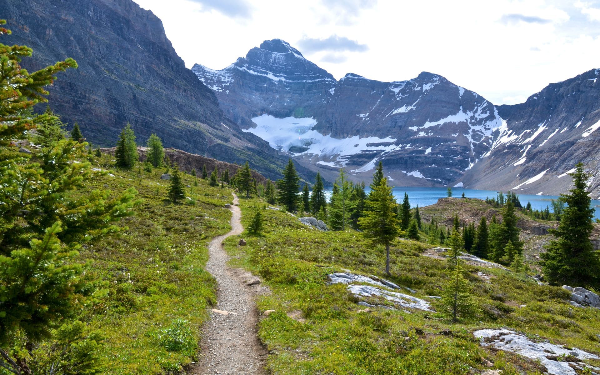
Grinnell Glacier Trail
Distance: 10.6 miles round trip | Difficulty: Moderate | Best months: mid-July through mid-September
This trail starts at the Many Glacier area on the east side of Glacier National Park, about a 45-minute drive from the St. Mary entrance. It climbs past Lake Josephine and Grinnell Lake to reach Grinnell Glacier itself, one of the park's diminishing but still visually striking ice fields. What most first-timers overlook: the park concessionaire runs a boat shuttle from the Many Glacier Hotel dock across Swiftcurrent Lake and Lake Josephine, cutting roughly 3 miles off each leg of the hike. Boat tickets run approximately $20 to $30 per person (labeled estimate; confirm current pricing with the park concessionaire before you go). Grizzly bear sightings are common in this drainage. Carry bear spray and stay alert on the upper trail, particularly in the berry-heavy slopes above treeline.
Avalanche Lake
Distance: 4.5 miles round trip | Difficulty: Easy to moderate | Best months: late May through October
If you're bringing children or want a high-reward hike without the full alpine commitment, Avalanche Lake is the most consistent option in Glacier. The trailhead sits on Going-to-the-Sun Road at the Avalanche Creek parking area, and the route begins through an old-growth stand of western red cedar and hemlock, one of the few remaining pockets of that forest type in Montana, before opening at a lake ringed by waterfalls dropping off the surrounding cliffs. Elevation gain is about 500 feet over 2.25 miles. Because the trail stays at lower elevation, it opens several weeks earlier than the park's high-country routes, often by late May, making it a good option if you're visiting before Logan Pass clears. This trail also connects with the Trail of the Cedars, a short, flat, wheelchair-accessible boardwalk loop near the trailhead.
Jewel Basin
Distance: Varies (35 miles of trail total) | Difficulty: Moderate | Best months: July through early October
Jewel Basin is a designated hiking area in the Swan Range above Bigfork, inside the Flathead National Forest. It covers roughly 15,000 acres with 35 miles of trail connecting 27 alpine lakes, and no bikes, horses, or motor vehicles are allowed anywhere inside it. That no-motorized rule gives Jewel Basin a noticeably quieter feel than most accessible alpine terrain in the region. The Camp Misery Trailhead, named for an old ranger station in the basin, is the main entry point and sits about 20 miles from Bigfork via Echo Lake Road and then Forest Road 5392. The drive up the forest road is rough enough that a high-clearance vehicle is helpful, though passenger cars make it in dry conditions. Jewel Basin fits naturally into a trip through Glacier Country, with Flathead Lake just below in the valley and Glacier National Park about an hour north.
Hyalite Canyon
Distance: 0.7 to 10 miles round trip | Difficulty: Easy to strenuous | Best months: April through November
About 12 miles south of Bozeman off South 19th Avenue via Hyalite Canyon Road (Forest Road 62), Hyalite Canyon gives you a range of hiking options in one drainage. Palisade Falls is 0.7 miles round trip on a paved, accessible path ending at a 90-foot waterfall, good for any fitness level. Grotto Falls is about 4.5 miles round trip through forest and creek crossings. For a full summit day, the route to Hyalite Peak in the Gallatin Range climbs to 10,299 feet in roughly 10 miles round trip with 3,500 feet of gain. Day use is free; camping requires a fee. It's the closest trail system to BZN airport, and if you land in Bozeman in the afternoon, you can hike the Palisade Falls trail the same evening. Hikers who want to extend their time in the Gallatin Range often pair a hiking day with time on the rivers flowing out of these same mountains. See the best fly fishing rivers in Montana for what's accessible from the same base.
Trapper Peak
Distance: approximately 7 miles round trip | Difficulty: Strenuous | Best months: July through September
At 10,157 feet, Trapper Peak is the highest summit in the Bitterroot Mountains, and the trail to the top is direct enough that most fit hikers can reach the summit and return in a single day. The trailhead is off West Fork Road, about 20 miles south of Darby on US-93, roughly 90 miles south of Missoula. From the trailhead at around 6,000 feet, the route climbs through forest before breaking into open scree on the upper mile. There's no shade and nowhere to shelter above treeline. Afternoon thunderstorms typically build over the Bitterroots by 2 or 3 p.m. in July and August, and they come in fast. Most experienced hikers on this peak start at first light and are back at the trailhead before noon. The summit view covers the full length of the Bitterroot Valley east to the Continental Divide and west to the Idaho border.
Beartooth Plateau Trails
Distance: Varies | Difficulty: Moderate to strenuous | Best months: July through September
Red Lodge sits at the base of the Beartooth Highway (US-212) and gives you access to some of the highest alpine terrain in the lower 48. The Beartooth Plateau sits mostly above 10,000 feet, with dozens of tarns, granite ridgelines, and wildflower meadows that peak in mid-July. Several trailheads line the highway, including the Basin Creek Lakes trail at roughly 6 miles round trip, and longer routes into the Rock Creek headwaters. Snow can remain on these trails into early July, and conditions shift fast at elevation, so check current reports before you go. Red Lodge is about 60 miles southwest of Billings via US-212. Summer weekends bring crowds to the main trailheads, but even moderate side trails off the plateau are quiet. Hotels and lodges in Red Lodge fill quickly from mid-June through August; book well ahead if you're planning a summer trip.
Mount Sentinel
Distance: 1.7 to 7 miles round trip | Difficulty: Easy to moderate | Best months: Year-round
The M Trail in Missoula starts at the end of Maurice Avenue and climbs 620 feet to the concrete M, which University of Montana students placed on the hillside in 1908. The round trip to the M is 1.7 miles. The trail continues past it to the Mount Sentinel summit at 5,158 feet, adding several more miles and about 1,400 additional feet of gain for a total of roughly 7 miles round trip if you go all the way. No reservation, no fee, no permit. The lower sections stay runnable even in winter with trail shoes, and the views over the Clark Fork River and the five valleys converging at Missoula are solid in any season. It's one of the few quality hikes in Montana that you can slot into the evening after you land at MSO airport.
Quick Comparison
The Highline and Grinnell Glacier trails are Glacier's two signature long day hikes, both in the same park but on different sides. Highline works best as a one-way shuttle hike; Grinnell is an out-and-back that rewards the boat shuttle option. Avalanche Lake is the right call for families or for May and June visits when Logan Pass is still closed. Jewel Basin is for travelers who want solitude and don't mind a forest-road drive. Hyalite Canyon is the go-to for a Bozeman base with multiple difficulty levels in one spot. Trapper Peak is the Bitterroot's best summit day if you're willing to do 4,000 feet of vertical. The Beartooth Plateau gives you high alpine without needing a backcountry permit, though you'll want a full day and an early start. Mount Sentinel is the only trail on this list you can walk from a city neighborhood, making it a year-round option and a good leg-stretch day.
If skiing brings you to Montana in winter, many of these same mountain ranges also host the best ski resorts in Montana once the snow falls.
Frequently asked questions
Do I need a permit to hike in Glacier National Park?
Most day hikes in Glacier do not require a separate permit, but driving Going-to-the-Sun Road does require a timed vehicle reservation during peak summer hours (typically 6 a.m. to 3 p.m., late June through early September). If you park outside the corridor and take the free park shuttle to trailheads like Logan Pass, you can avoid the vehicle reservation requirement. There is no additional permit needed for the Highline Trail, Grinnell Glacier Trail, or Avalanche Lake. Overnight backcountry camping does require a permit, which goes through Glacier's permit system starting in mid-March for the peak season.
When do high-alpine trails in Montana open?
It depends on the elevation and the snowpack that year. Lower trails like Avalanche Lake in Glacier and the M Trail in Missoula can be clear by late April or early May. Mid-elevation trails like those in Jewel Basin typically open in late June or early July. High-alpine terrain on the Highline Trail, the Beartooth Plateau, and Trapper Peak often holds snow through late June and sometimes early July. Always check current conditions with the relevant park or forest service district before you go, especially for the Beartooth Plateau, where trail conditions can shift significantly from one week to the next.
Do I need bear spray on Montana trails?
Yes, on most Montana backcountry trails, and especially in Glacier National Park. Glacier has one of the highest grizzly bear densities of any park in the lower 48, and the Grinnell Glacier Trail in particular sees regular grizzly activity. Bear spray is proven effective in bear encounters and is widely available at gear shops in Whitefish, Kalispell, and near the park entrances, with rentals available for roughly $10 to $15 per day (estimate). Carry it accessible, not buried in your pack. Stay in groups, make noise on the trail, and keep distance from all wildlife. Black bears are present on trails throughout the state, including the Bitterroot and Gallatin ranges.
Which of these hikes are good for beginners or families with young children?
Avalanche Lake in Glacier is the strongest option: 4.5 miles round trip with a manageable 500 feet of elevation gain and a beautiful payoff at the lake. The Trail of the Cedars boardwalk adjacent to it is flat and wheelchair accessible. In Missoula, the M Trail to the concrete M is 1.7 miles with a good view and a clear turnaround point. Palisade Falls in Hyalite Canyon near Bozeman is 0.7 miles round trip on a paved accessible path. All three are doable for most kids over about age 6, and none require permits.